RTK positioning that achieves high-precision positioning.
GNSS positioning can be broadly divided into standalone positioning and relative positioning, with RTK positioning being one type of relative positioning. Utilizing RTK positioning is effective for achieving high-precision positioning. Its positioning accuracy is said to be within a few centimeters. ALES's "centimeter-level positioning service" is a service that uses RTK positioning.

Inquire About This Product
basic information
At ALES Corporation, we utilize the signals received from SoftBank Corporation's unique reference points to generate and distribute correction information through the ALES distribution system. By using the generated/distributed correction information along with the signals received by GNSS receivers (mobile stations), high-precision positioning with an accuracy of a few centimeters can be achieved in real time through RTK positioning. By applying corrections with the correction information, it becomes possible to provide high-precision location information for agricultural machinery, drones, construction equipment, autonomous vehicles, and more.
Price range
Delivery Time
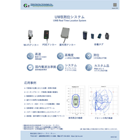
Applications/Examples of results
For details, please contact us.
catalog(3)
Download All Catalogs


Company information

ALES Corporation is a company established in July 2018 through a joint investment by SoftBank Corp. and Enabler Inc., which has technical expertise in satellite positioning. Based on the signals received by SoftBank's unique reference points, ALES generates correction information using the "ALES Distribution System (*1)" and provides the necessary correction information for high-precision positioning to GNSS (*2) receivers (including dedicated devices, smartphones, etc.), or performs correction calculations on the cloud to directly deliver highly accurate location information to GNSS receivers, enabling centimeter-level positioning services. Please feel free to contact us if you have any inquiries. *1 The ALES Distribution System is our proprietary high-precision positioning information distribution system based on RTK (Real Time Kinematic) positioning. *2 GNSS (Global Navigation Satellite System) refers to the general term for satellite positioning systems such as QZSS (Quasi-Zenith Satellite System), GPS, GLONASS, and Galileo.