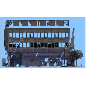
Lightweight point cloud data (patented) [Examples of 3D point cloud editing applications]
Introducing examples of WingEarth applications: Reduce data size while maintaining shape!
WingEarth, handled by Aisan Technology, is a large-scale point cloud editing tool that can rapidly process point cloud data exceeding 10 billion points, based on three-dimensional point cloud processing capabilities. 【Use Cases for the 3D Point Cloud Editing Tool (WingEarth)】 ◆General Operations ◆Lightweight Point Cloud Data (Patent Obtained) → By utilizing the edge extraction function, the data size can be reduced while preserving features. The lightweight data retains key points, improving the efficiency of tracing tasks. 【Key Points】 - It is possible to reduce the data size while maintaining the shape features. - The data size can be reduced to about 1/10 when outputting only edges. *You can check the collection of use cases from the PDF download. Please feel free to contact us for more product details.
Inquire About This Product
basic information
**Features of WingEarth** - Compatible with i-Construction - Easy video creation - Export to 3D PDF - Comfortable operability in three-dimensional space - Effective display functions for planar processing - Full utilization of surveying and design data - Automatic object recognition - Point cloud grouping and extraction - Ground filtering and filling - Capable of calculating cut and fill volumes - Abundant input and output options **Types of Output** Planar output, point cloud output, surveying data, mesh output, shape output, cross-section output, orthophoto output, heatmap output *For more details, please refer to the PDF materials or feel free to contact us.*
Price range
Delivery Time
Applications/Examples of results
For more details, please refer to the PDF document or feel free to contact us.
Detailed information
-

Data compression while preserving the feature points of the point cloud.
catalog(2)
Download All Catalogs

Company information

Aisan Technology primarily serves customers from industries related to public works, including "surveying and design," "construction," and "land and house investigator services" involved in real estate registration. Our fundamental approach is to propose "analysis technologies that seek more accurate positioning" to our customers, and we offer a variety of software and services as products that can flexibly respond to the various challenges faced by each industry and business.
![Digital Measurement Utilizing 3D Scanners [Examples of 3D Point Cloud Editing]](https://image.mono.ipros.com/public/product/image/918/2000428344/IPROS16672019999229576916.png?w=280&h=280)
![Integration with 3D Building Systems [Examples of Utilizing 3D Point Cloud Editing]](https://image.mono.ipros.com/public/product/image/46b/2000429461/IPROS5373707527362870529.jpg?w=280&h=280)
![Creation of Current Situation Maps [Example of 3D Point Cloud Editing Utilization]](https://image.mono.ipros.com/public/product/image/8a6/2000429492/IPROS12317152004194140947.jpg?w=280&h=280)
![Review of the slope of the promenade [Example of 3D point cloud editing application]](https://image.mono.ipros.com/public/product/image/c67/2000432036/IPROS13318682353174873464.jpg?w=280&h=280)


![[For those considering a machining center with subsidies] Completely free subsidy application support](https://image.mono.ipros.com/public/product/image/9e8/2001018356/IPROS11318484018947278323.png?w=280&h=280)


