We have compiled a list of manufacturers, distributors, product information, reference prices, and rankings for Receiver.
ipros is IPROS GMS ・ IPROS One of the largest technical database sites in Japan that collects information on.

Receiver Product List and Ranking from 124 Manufacturers, Suppliers and Companies | IPROS GMS

Last Updated: Aggregation Period:Oct 07, 2026~Nov 03, 2026
This ranking is based on the number of page views on our site.

Receiver Manufacturer, Suppliers and Company Rankings

Last Updated: Aggregation Period:Oct 07, 2026~Nov 03, 2026
This ranking is based on the number of page views on our site.

  1. Jコーポレーション Nara//Information and Communications
  2. HERUTU ELECTRONICS CORPORATION Shizuoka//Industrial Electrical Equipment
  3. 野村エンジニアリング 本社 Kanagawa//Industrial Electrical Equipment
  4. 4 安震 Aichi//Rubber products
  5. 5 長谷川機材 Tokyo//Industrial Machinery

Receiver Product ranking

Last Updated: Aggregation Period:Oct 07, 2026~Nov 03, 2026
This ranking is based on the number of page views on our site.

  1. Vibration call and emergency alert wristwatch-type receiver 野村エンジニアリング 本社
  2. Emergency Earthquake Alert Receiver "Super Namazu" - Earthquake, Disaster Prevention, and BCP Measures Supplies Jコーポレーション
  3. Aichi Tokei Denki Individual Receiver for Pulse Emission Meters 長谷川機材
  4. 4 4-point output type Poka-Yoke receiver TW-800R-EXP HERUTU ELECTRONICS CORPORATION
  5. 4 Urethane gel "Hapla Pringel" with a texture that is infinitely close to human skin. ポリシス

Receiver Product List

301~330 item / All 408 items

Displayed results

[Earthquake Countermeasure Example] Break Room Edition [Seismic Adjuster]

We have products that can accommodate dish cabinets and refrigerators! Introducing examples of earthquake-resistant adjusters! [Video and case study collection available]

The office's break room is a small space, so there is a possibility that shelves or refrigerators could fall and block evacuation routes, trapping people inside. Additionally, in break rooms without IH (induction heating), there is a risk of fire due to shelves falling on water heaters or stoves, making preemptive earthquake measures with seismic adjusters important. 【Target Items】 ■Dish rack ■Refrigerator *For more details, please refer to the PDF document or feel free to contact us. 【Official Instagram】: Currently showcasing construction examples ★☆ https://www.instagram.com/ansin_official/ 【Official Website】: For inquiries, please contact us at the link below! http://www.ans1828.com 【Introduction Video】 https://youtu.be/1oE7CAwOvZQ

  • Other safety equipment
  • Receiver

Added to bookmarks

Bookmarks list

Bookmark has been removed

Bookmarks list

You can't add any more bookmarks

By registering as a member, you can increase the number of bookmarks you can save and organize them with labels.

Free membership registration

Examples of Earthquake Countermeasures: Station and Theme Park Edition - Seismic Isolation Adjuster

Earthquake measures for station premises and theme parks! Avoid and mitigate the risks of coin lockers! [Video and case study collection available]

Coin lockers are used daily by a large number of unspecified people. They are often installed in narrow spaces, and multiple coin lockers are set up together. In the event of an earthquake, they may topple over and block evacuation routes, potentially leading to human disasters. By installing earthquake-resistant adjusters in advance, these risks can be avoided or mitigated. 【Target Object】 ■ Coin Lockers *For more details, please refer to the PDF document or feel free to contact us. 【Official Instagram】: Currently showcasing case studies★☆ https://www.instagram.com/ansin_official/ 【Official Website】: For inquiries, please contact us at the link below! http://www.ans1828.com 【Introduction Video】 https://youtu.be/1oE7CAwOvZQ

  • Other safety equipment
  • Receiver

Added to bookmarks

Bookmarks list

Bookmark has been removed

Bookmarks list

You can't add any more bookmarks

By registering as a member, you can increase the number of bookmarks you can save and organize them with labels.

Free membership registration

[Earthquake Countermeasure Examples] Apartment Edition [Seismic Adjuster]

Earthquake measures for condominiums! Install seismic adjusters to avoid and reduce risks [Video and case study collection available].

Due to the damage caused by heat pump water heaters toppling over in the shared hallways of the condominium during an earthquake, resulting in a large amount of hot water flowing out into the hallway, earthquake countermeasures are essential. However, using anchor fixation would require drilling holes in the floor of the condominium, and when replacing units, the new models often have different leg sizes, necessitating new holes to be drilled, which can weaken the floor and render the anchors ineffective. The Anshin Adjuster is an earthquake countermeasure that can be installed without drilling holes in the floor, leaving no marks or holes and maintaining the floor's strength. 【Target Object】 ■ Heat Pump Water Heater *For more details, please refer to the PDF materials or feel free to contact us. 【Official Instagram】: Currently showcasing case studies ★☆ https://www.instagram.com/ansin_official/ 【Official Website】: For inquiries, please contact us below! http://www.ans1828.com 【Introduction Video】 https://youtu.be/1oE7CAwOvZQ

  • Other safety equipment
  • Receiver

Added to bookmarks

Bookmarks list

Bookmark has been removed

Bookmarks list

You can't add any more bookmarks

By registering as a member, you can increase the number of bookmarks you can save and organize them with labels.

Free membership registration

What is the structure and mechanism of the earthquake-resistant product "Anshin Adjuster"?

Corresponds to seismic intensity 7! Triple seismic isolation effect to prevent vertical and horizontal shaking, with double load-bearing effect of shock-absorbing gel and high-damping rubber [Video & case study collection available].

The "Anshin Adjuster" is an earthquake-resistant product that can be installed without driving anchor bolts. It allows for easy attachment to machine legs without the need to drill holes in the floor. This product is made from a special urethane with shock-absorbing properties and high-damping rubber that prevents collapse, known as Gel Anshin V3. It exhibits excellent performance through the combination of a "dedicated jig" that creates play in Gel Anshin V3 to significantly enhance its seismic (shock-absorbing) performance, and a dedicated adhesive called "Anshin Aiba," which has deformation-following characteristics. 【Structure and Mechanism】 ■ Anshin V3: Controls lateral shaking with the characteristics of high-damping rubber ■ Dedicated Jig: Controls lateral shaking with the properties of special urethane and space ■ Anshin Aiba: Controls vibrations and shocks with the properties of the adhesive *This product has basically undergone seismic testing equivalent to a seismic intensity of 7, but it does not guarantee the prevention of damage caused by equipment during an earthquake. 【Official Instagram】: Currently showcasing installation examples★☆ https://www.instagram.com/ansin_official/ 【Official Website】: For inquiries, please contact us at the following! http://www.ans1828.com 【Introduction Video】 https://youtu.be/1oE7CAwOvZQ

  • Rubber
  • Receiver

Added to bookmarks

Bookmarks list

Bookmark has been removed

Bookmarks list

You can't add any more bookmarks

By registering as a member, you can increase the number of bookmarks you can save and organize them with labels.

Free membership registration

"Anshin Adjuster" L-shaped type *Construction manual is also being distributed.

Triple seismic isolation effect to prevent horizontal and vertical shaking! Introduction of installation manual [with video and case studies].

The "Anshin Adjuster" is an earthquake-resistant product that can be installed without driving anchor bolts. It allows for installation without making holes in the floor, making it easy to attach to the legs of machinery. It is also perfect for places where layouts are frequently changed. The Anshin Adjuster "L Corner Type" is a specialized tool suitable for the shapes of legs such as those found on pipe racks. This document introduces the items you need to prepare before installation, as well as the installation procedures and key points in the installation manual. 【Anshin L Corner Tool】 ■ Dimensions - Total length: 90mm, External dimensions: 80mm x 80mm ■ Load capacity: Maximum 500kg (per leg) ■ Material: Stainless steel (SUS304) ■ Anshin V3: 50 square *For more details, please download the PDF or feel free to contact us. 【Official Instagram】: Currently showcasing installation examples★☆ https://www.instagram.com/ansin_official/ 【Official Website】: For inquiries, please contact us below! http://www.ans1828.com 【Installation Manual Video】 https://youtu.be/gFh-5mCh2Aw

  • Rubber
  • Receiver

Added to bookmarks

Bookmarks list

Bookmark has been removed

Bookmarks list

You can't add any more bookmarks

By registering as a member, you can increase the number of bookmarks you can save and organize them with labels.

Free membership registration

"Anshin Adjuster" R-shaped Fixture [Video & Installation Manual Available]

Anti-shake adjuster with triple seismic isolation effect to prevent horizontal and vertical shaking! Introduction to the construction manual.

The "Anshin Adjuster" is an earthquake-resistant product that can be installed without driving anchor bolts. It allows for installation without making holes in the floor and makes it easy to attach to machine legs. It is perfect for places where layouts are frequently changed. The Anshin Adjuster "R Corner Type Jig" is a dedicated jig that supports existing legs. Please be sure to use the dedicated adhesive Anshin Aiva for installation. This document introduces the items you need to prepare before installation, as well as the installation procedures and key points in the installation manual. 【R Corner Type Jig Specifications】 ■ Dimensions - Width: 80 mm, Total Length: 113 mm, Height: 48 mm ■ Load Capacity: Supports seismic intensity of about 6 and prevents tipping ■ Material: SUS304 ■ Anshin V3 / Anshin Gel: 50 square 【Official Instagram】: Currently showcasing installation examples★☆ https://www.instagram.com/ansin_official/ 【Official Website】: For inquiries, please contact us below! http://www.ans1828.com 【Installation Manual Video】 https://youtu.be/2GXXE7BbC6I

  • Rubber
  • Receiver

Added to bookmarks

Bookmarks list

Bookmark has been removed

Bookmarks list

You can't add any more bookmarks

By registering as a member, you can increase the number of bookmarks you can save and organize them with labels.

Free membership registration

[Earthquake Measures] Consideration of Introducing Seismic Adjusters [Step 1]

★Must-see★ Earthquake measures that do not require drilling holes in the floor! This is a reference document for considering the introduction of the 'Anshin Adjuster'.

When considering the introduction of earthquake countermeasures, one of the concerns that may arise is whether "the products can be implemented under your company's usage conditions." For companies that feel it might be a bit early to inquire about whether the Anshin Adjuster can be introduced, we hope you will find this information helpful. From the download section below, you can view the flowchart format for: - Anshin Adjuster usability (floor version) - Anshin Adjuster usability (target object version) We would greatly appreciate it if you could make use of this information. We understand that there may still be many unclear points, so please feel free to contact us with any questions, no matter how small. We are here to help. 【Official Instagram】: Currently showcasing case studies ★☆ https://www.instagram.com/ansin_official/ 【Official Website】: For inquiries, please contact us at the link below! http://www.ans1828.com 【Introduction Video】 https://youtu.be/1oE7CAwOvZQ

  • Other Auto Parts
  • Receiver

Added to bookmarks

Bookmarks list

Bookmark has been removed

Bookmarks list

You can't add any more bookmarks

By registering as a member, you can increase the number of bookmarks you can save and organize them with labels.

Free membership registration

[Experimental Video Collection] Public Release of Seismic Experiment Footage at Shindo 7!! [Earthquake Countermeasures for Factories]

★Must-see★ This is a ranking of vibration experiment videos conducted by an earthquake prevention manufacturer using their own equipment! Earthquake measures that can withstand shaking of seismic intensity 7 without making holes in the floor.

We are Ansin Co., Ltd., engaged in the development and sales of earthquake measures that do not create holes in the floor, known as the Ansin Adjuster. Our company owns a shaking device and conducts experiments regularly. This time, we are featuring our "Top 3 Recommended Experiment Videos!" 1st Place: "Carpet Vibration Experiment" https://youtu.be/EjNc0jOuD5g *Point* This is an experimental video using the newly released "Pitatto Carpet." It's a must-see for measures in offices and carpeted floors! 2nd Place: "Glass Case Experiment Video" https://youtu.be/sVXq5xWzPdE *Point* Earthquake measures for glass cases are filmed in two patterns: 1. No measures taken at all, and 2. Fixed with the Ansin Adjuster. You can see the dangers of having no measures in place. 3rd Place: "Seismic Isolation (Shock Absorption) Effect Test with Ansin Adjuster" https://youtu.be/07n1NO6RaaA *Point* You can clearly see the shock absorption performance of our gel. ⇒ Other experimental videos are also available on our website https://ans1828.com/movie-list/

  • Engine parts
  • Receiver

Added to bookmarks

Bookmarks list

Bookmark has been removed

Bookmarks list

You can't add any more bookmarks

By registering as a member, you can increase the number of bookmarks you can save and organize them with labels.

Free membership registration

Guest Receiver ZERO for truck drivers waiting in line

[No personal information required] A contractor is running to inform about the call for standby trucks. There's no need for drivers to search anymore!

Are logistics warehouse operators having trucks wait nearby and calling drivers when it's their turn? With Guest Receiver ZERO, when the driver arrives at the reception, we hand them a small receiver, and when it's their turn, we notify them by pressing the number of the corresponding receiver on the transmitter. Once loading and unloading are completed, the receiver is returned. This allows us to inform drivers without using personal information such as mobile phone numbers.

  • Other safety and hygiene products
  • Receiver

Added to bookmarks

Bookmarks list

Bookmark has been removed

Bookmarks list

You can't add any more bookmarks

By registering as a member, you can increase the number of bookmarks you can save and organize them with labels.

Free membership registration

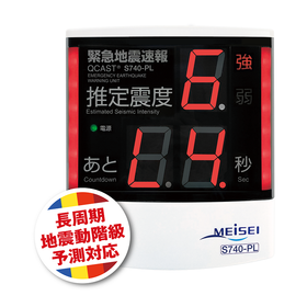
QCAST Series Emergency Earthquake Alert Receiving Unit S740

This is a general-purpose receiving unit that calculates and displays estimated seismic intensity and warning time before a strong tremor arrives, in response to an "Emergency Earthquake Alert," along with audio announcements.

■Direct reception is possible from highly reliable distribution operators such as the Meteorological Agency. ■Receives information for advanced users, displaying pinpoint estimated seismic intensity and countdown for grace period. ■Broadcast linkage can be easily achieved without worrying about cutoff. ■Provides large, easy-to-read displays with industry-leading visibility.

  • Other environmental equipment
  • others
  • Receiver

Added to bookmarks

Bookmarks list

Bookmark has been removed

Bookmarks list

You can't add any more bookmarks

By registering as a member, you can increase the number of bookmarks you can save and organize them with labels.

Free membership registration

Emergency Earthquake Alert Telephone Paging Device EDR-200A

Receiving the "Emergency Earthquake Alert" from FM radio broadcasting, a unique evacuation guidance announcement is broadcasted throughout the facility! Introduced with low cost and easy installation!

By receiving the "Emergency Earthquake Alert" broadcast from commercial FM radio stations and NHK-FM radio stations, and using a broadcasting amplifier or an internal exchange system with paging broadcast functionality, it is possible to conduct earthquake alert broadcasts to inform about the occurrence of an earthquake. ● Utilizes the chime of the "Emergency Earthquake Alert" from FM radio broadcasts, eliminating the need for dedicated receiving terminals or running costs. ● Compatible with Wide FM (FM supplementary broadcasting), allowing the frequency of the received FM broadcast to be set within the range of 76MHz to 99.9MHz. ● By connecting this device to a broadcasting amplifier, it is possible to broadcast emergency earthquake alerts from existing broadcasting equipment. ● Utilizing the paging broadcast function of the exchange system, earthquake alerts can be broadcast from connected telephones or speakers of broadcasting equipment. ● Custom announcements can be recorded and broadcasted. It supports disaster reduction through appropriate evacuation guidance tailored to the facility or environment. ● Test broadcasts can confirm the operation of the device and conduct evacuation drills. ● Can output contact signals, which can be used for emergency stops and control of various equipment.

  • Other PCs and OA equipment
  • Receiver

Added to bookmarks

Bookmarks list

Bookmark has been removed

Bookmarks list

You can't add any more bookmarks

By registering as a member, you can increase the number of bookmarks you can save and organize them with labels.

Free membership registration

Call bell Urban Call 20 three-slot receiver

Capture customer feedback reliably! Operate smartly with ease!

●If calls overlap, they will be saved in memory, so you can focus during busy times without missing any calls, providing peace of mind. ●The number extinguishing can be set for a duration (5 to 98 seconds or infinite) and will turn off automatically. If you send a signal again while it is lit, it will blink four times to notify you of a duplicate call. ●Adding a send button or changing numbers can be done easily, allowing for immediate adjustments when rearranging desks or adding new setups. ●When you want to display different floors separately, you can set your preferred numbers by floor. ●You can use it immediately by plugging it into an outlet, and no wiring work is needed, so you can start using it from the day it arrives. ●If false alarms occur due to interference, they can be easily avoided with simple operations, so there is no concern about interference in the future.

  • others
  • Receiver

Added to bookmarks

Bookmarks list

Bookmark has been removed

Bookmarks list

You can't add any more bookmarks

By registering as a member, you can increase the number of bookmarks you can save and organize them with labels.

Free membership registration

Case Studies of Network RTK Utilization: "Land and House Surveyor Services"

Introducing examples of the use of "network-type RTK" in the field of land and building surveying.

This document introduces examples of the use of a unique technology (JENOBA method) utilizing real-time data from electronic reference points in the field of land and house surveying with "network-based RTK." It includes examples of applications such as "initiatives for registration surveying," "boundary determination surveying," and "integration with land and house surveying." Compared to traditional static surveying, it demonstrates significant reductions in working time. 【Examples Included】 ■ Initiatives for network-based RTK registration surveying (Kumamoto Prefecture Land and House Surveyors Association) ■ Application of network-based RTK in boundary determination surveying (Land and House Surveyor Yoichi Suzuki Office) ■ Case of integration between land and house surveying and network-based RTK (Omura GPS Research Group) *For more details, please refer to the catalog or feel free to contact us.

  • Other measurement, recording and measuring instruments
  • others
  • Receiver

Added to bookmarks

Bookmarks list

Bookmark has been removed

Bookmarks list

You can't add any more bookmarks

By registering as a member, you can increase the number of bookmarks you can save and organize them with labels.

Free membership registration

Case Studies on the Use of Network RTK: "Verification/Academic"

Introduction of verification and case studies of "network-type RTK" in academic fields.

This document introduces the verification and academic application examples of a unique technology (JENOBA method) that utilizes real-time data from electronic reference points in the "network-type RTK." It includes examples such as "experimental verification of static surveying using network-type static and electronic reference points" and applications in "surveying investigations of large ancient tombs." It has been demonstrated that preliminary surveys do not require significant time or cost, allowing for immediate surveying work with preparations made the day before, showcasing benefits not only in general surveying but also in archaeological investigations. 【Published Examples】 ■ Experimental verification of static surveying using network-type static and electronic reference points (Urban Design Engineering Department, Osaka Institute of Technology, Surveying and Geotechnical Research Laboratory) ■ Application example of network-type RTK in the surveying investigation of large ancient tombs (Archaeology Research Laboratory, Okayama University) *For more details, please refer to the catalog or feel free to contact us.

  • Other measurement, recording and measuring instruments
  • others
  • Receiver

Added to bookmarks

Bookmarks list

Bookmark has been removed

Bookmarks list

You can't add any more bookmarks

By registering as a member, you can increase the number of bookmarks you can save and organize them with labels.

Free membership registration

Collection of Case Studies on Network RTK Utilization: "Other Application Examples"

Introducing other application examples of "network-type RTK."

This document introduces application examples of the "network-type RTK" that employs a unique technology (JENOBA method) utilizing real-time data from electronic reference points. It includes applications such as "measurement using the Mitsubishi Mobile Mapping System (MMS) high-precision mobile measurement device," as well as examples from the "unmanned rice planting machine system" and the "snow removal support system." 【Published Examples】 ■ Measurement case using the Mitsubishi Mobile Mapping System (MMS) high-precision mobile measurement device (Toyonaka City, Osaka Prefecture) ■ Example of network-type RTK utilization in the unmanned rice planting machine system (National Agriculture and Food Research Organization) ■ Application of network-type RTK in the snow removal support system (Tateyama Route Snow Removal Association) *For more details, please refer to the catalog or feel free to contact us.

  • Other measurement, recording and measuring instruments
  • others
  • Receiver

Added to bookmarks

Bookmarks list

Bookmark has been removed

Bookmarks list

You can't add any more bookmarks

By registering as a member, you can increase the number of bookmarks you can save and organize them with labels.

Free membership registration

Collection of Case Studies on Network RTK Utilization: "GNSS Demonstration Experiment"

Introducing examples of the use of "network-type RTK" in GNSS demonstration experiments.

This document introduces case studies from a GNSS demonstration experiment utilizing a unique technology (JENOBA method) based on real-time data from electronic reference points, specifically in the context of "network-type RTK." It includes information on the "multi-GNSS demonstration experiment," as well as the usefulness of "buggy surveying" and "network-type multi-GNSS delivery under adverse conditions." The high utility of multi-GNSS has been confirmed for further efficiency in extensive construction management surveying, especially under adverse conditions where the number of receiving satellites is often limited. 【Published Case Studies】 ■ Multi-GNSS Demonstration Experiment [Hokkaido Region] (Iwasaki Co., Ltd.) ■ Demonstration of Network-type GNSS Utilization through Buggy Surveying (Positioning Satellite Technology Co., Ltd.) ■ Demonstration Experiment on the Usefulness of Network-type Multi-GNSS Delivery under Adverse Conditions (Senar and Burns Co., Ltd.) *For more details, please refer to the catalog or feel free to contact us.

  • Other measurement, recording and measuring instruments
  • others
  • Receiver

Added to bookmarks

Bookmarks list

Bookmark has been removed

Bookmarks list

You can't add any more bookmarks

By registering as a member, you can increase the number of bookmarks you can save and organize them with labels.

Free membership registration

[Example] Road ledger annex drawing modification work

Adoption of network-type RTK-GPS for road ledger attachment modification work!

We would like to introduce a case study where the Kansai Division of Pasco Co., Ltd. adopted a network-type RTK-GPS using the JENOBA method for the "Road Ledger Appendix Modification Work." The site is a general national road under the jurisdiction of the Osaka National Highway Office, with a total length of approximately 85 km. Due to the short construction period of 4 months, it was necessary to consider the work methods and processes. Given the work conditions, we established a policy for improving quality and accuracy, particularly in the measurement of reference points, which involved GPS static surveying using electronic reference points and the implementation of network-type RTK-GPS using the JENOBA method (both indirect and direct methods with a single receiver). 【Solution】 - Adopted network-type RTK-GPS using the JENOBA method for the installation of relevant reference points. - For areas with poor overhead visibility during reference point surveying, a combination of GPS and total stations (TS) was used. - Implemented a point allocation plan that took into account areas under construction. - Considered the efficiency of work through planning that accounted for existing and planned reference points from other agencies. - Established reference points within the system (including those from other agencies) and introduced an inspection system using ArcGIS. *For more details, please refer to the PDF document or feel free to contact us.

  • Other network tools
  • Other measurement, recording and measuring instruments
  • Receiver

Added to bookmarks

Bookmarks list

Bookmark has been removed

Bookmarks list

You can't add any more bookmarks

By registering as a member, you can increase the number of bookmarks you can save and organize them with labels.

Free membership registration

[Example] Construction of a Surveying Work Manual

Utilizing the single-point observation method of network RTK-GPS surveying in the field of geodetic surveying as public surveying!

We would like to introduce a case study by the City of Tondabayashi, Osaka Prefecture (in cooperation with Asahi Koyo Co., Ltd.) regarding the "Construction of a Surveying Work Manual," utilizing reference points (star measurement points) through network-type RTK single-point observation. To conduct third and fourth-class reference point surveys, which form the backbone of construction surveying, as public surveys, it is necessary to use higher-level national reference points or public reference points as known points. However, in areas where the density is not sufficiently developed for efficient use, there can be an excessive financial burden. As a result, these surveying works may not be applied to the Geospatial Information Authority of Japan as public surveys, and the surveying results have rarely been utilized beyond the specific construction projects. 【Solution】 - Developed a single-point observation method using network-type RTK-GPS in collaboration with Asahi Koyo Co., Ltd. in the field of geodetic surveying. - Received advice from the Geospatial Information Authority of Japan based on the application under Article 16 of the Public Survey Work Regulations. - Utilized the single-point observation method of network-type RTK-GPS surveying as public surveying in the field of geodetic surveying. *For more details, please refer to the PDF document or feel free to contact us.

  • Other network tools
  • Other measurement, recording and measuring instruments
  • Receiver

Added to bookmarks

Bookmarks list

Bookmark has been removed

Bookmarks list

You can't add any more bookmarks

By registering as a member, you can increase the number of bookmarks you can save and organize them with labels.

Free membership registration

[Example] Benchmark Survey Using Network RTK Single Point Observation

Conducting surveying based on the manual for surveying reference points (star measurement points) using single-point observation with RTK-GPS!

We would like to introduce a case study by Geotechnical Co., Ltd. utilizing network-type RTK single-point observation in "benchmark surveying." The site had 7 new points and 2 reference points. Based on the distances between these points, it was estimated that surveying using a total station would take about 5 days. Therefore, surveying was conducted according to the "Manual for Benchmark (Star Point) Surveying Using RTK-GPS Single-Point Observation." The survey using star points was completed in 2 days (effectively 1 hour) of observation. 【Solution】 ■ Conducted surveying according to the "Manual for Benchmark (Star Point) Surveying Using RTK-GPS Single-Point Observation" ■ Pre-planned the observation ■ Focused on the time frame from 2 PM to 6 PM when both the number and arrangement of satellites were favorable *For more details, please refer to the PDF document or feel free to contact us.

  • Other network tools
  • Other measurement, recording and measuring instruments
  • Receiver

Added to bookmarks

Bookmarks list

Bookmark has been removed

Bookmarks list

You can't add any more bookmarks

By registering as a member, you can increase the number of bookmarks you can save and organize them with labels.

Free membership registration

[Example] Application to Continuous Elevation Measurement of Mobile Bodies

Introducing the application of FKP-GPS measurement and ultrasonic level meters for continuous elevation measurement of moving objects!

We would like to introduce a case study conducted by Shin Gijutsu Consulting Co., Ltd. on the Chitose River embankment, titled "Application of FKP-GPS Surveying and Ultrasonic Level Measurement for Continuous Elevation Measurement of Moving Bodies." The site is located between 7.0 km and 12.0 km of the first-class river Chitose River, which flows through Ebetsu City and Chitose and Eniwa Cities. To understand the condition of the construction reference surface of the embankment built on soft ground, continuous elevation measurements using moving bodies were conducted, along with a comparative verification against direct leveling surveys. The vehicle was equipped with a high-precision GPS receiver and an aerial level meter, obtaining coordinate values and indirect elevation values every second using the FKP method. Additionally, the comparison with direct leveling involved direct elevation observations at the points where the level meter sensor made contact. Comparative measurements were taken at 77 identical points over a 3 km section on both the right and left banks. [Results (excerpt)] ■ Comparison with direct leveling (KP standard) - Less than 5 cm: 68.8%, less than 10 cm: 97.4% ■ Comparison with existing reference point results - Maximum ΔX 0.022m, ΔY 0.013m, ΔH 0.022m - Standard deviation ΔX 0.010m, ΔY 0.007m, ΔH 0.010m *For more details, please refer to the PDF document or feel free to contact us.

  • Other network tools
  • Other measurement, recording and measuring instruments
  • Receiver

Added to bookmarks

Bookmarks list

Bookmark has been removed

Bookmarks list

You can't add any more bookmarks

By registering as a member, you can increase the number of bookmarks you can save and organize them with labels.

Free membership registration

[Case] Flood Area Determination Business during Flooding

Utilizing network RTK in flood area determination operations!

We would like to introduce a case study by Souya Surveying Co., Ltd. that utilized network-based RTK in the "Flood Area Determination Work." In this case, topographic surveys were conducted using the network-based RTK method to determine the flood areas during flooding. The survey involved measuring the positions and heights of open drainage and buried pipes in agricultural land. Traditionally, this would have been done using a total station and leveling equipment, but we conducted accuracy verification of the network-based RTK-GPS and proposed it to the client. The work proceeded smoothly without issues related to satellite conditions or overhead visibility, and we were able to complete it in about a month and a half. 【Benefits and Effects】 ■ Significant efficiency improvement ■ Only one set of receivers is needed for the work, making it very effective as an initial investment. *For more details, please refer to the PDF document or feel free to contact us.

  • Other network tools
  • Other measurement, recording and measuring instruments
  • Receiver

Added to bookmarks

Bookmarks list

Bookmark has been removed

Bookmarks list

You can't add any more bookmarks

By registering as a member, you can increase the number of bookmarks you can save and organize them with labels.

Free membership registration

[Example] Establishment of Class 3 Benchmark Points for Agricultural Land Adjustment

Obtain coordinate values in just a few seconds! Establish reference points using network-based RTK-GPS!

We would like to introduce a case in which Kyoujin Surveying and Design Co., Ltd. applied network-type RTK-GPS for the installation of Class 3 reference points for agricultural land adjustment. In this case, we utilized a PAS compatible with network-type RTK-GPS for the installation work of Class 3 reference points for agricultural land adjustment. [Work Overview] - Distance from starting point to endpoint: 3 km - A total of 6 reference points were observed. *For more details, please refer to the PDF document or feel free to contact us.

  • Other network tools
  • Other measurement, recording and measuring instruments
  • Receiver

Added to bookmarks

Bookmarks list

Bookmark has been removed

Bookmarks list

You can't add any more bookmarks

By registering as a member, you can increase the number of bookmarks you can save and organize them with labels.

Free membership registration

[Example] Positioning of drilling locations and elevation measurement associated with geological surveys.

Observation of reference points using network RTK! The entire work was completed in 2 days.

We would like to introduce a case where Yamaguchi Land Survey Co., Ltd. utilized network-type RTK in "Boring position determination and elevation measurement associated with geological surveys." In this case, we were commissioned to determine the position and elevation of borings during a geological survey for a new road construction project. The survey area was nearly 10 km, with 20 separate survey points, making it likely that standard benchmark surveying and leveling would take more than 10 days to complete. Additionally, the points were located far from nearby triangulation points, which would require excessive labor for leveling. Due to these factors and requests from the client, we conducted the work using network-type RTK. 【Overview of Work】 1. Coordinate the survey points determined based on the outline planning map and conduct measurement work. 2. Conduct benchmark observations using network-type RTK. 3. Confirm the local position and elevation through coordinate calculations. *For more details, please refer to the PDF document or feel free to contact us.

  • Other network tools
  • Other measurement, recording and measuring instruments
  • Receiver

Added to bookmarks

Bookmarks list

Bookmark has been removed

Bookmarks list

You can't add any more bookmarks

By registering as a member, you can increase the number of bookmarks you can save and organize them with labels.

Free membership registration

[Example] Topographic Survey

Introducing examples of terrain surveying using network-type RTK!

We would like to introduce a case study by Shasoku Co., Ltd. that utilized network-based RTK in "topographic surveying." The site was a 9-hectare area of cultivated land and riverbed for topographic surveying. Approximately 1,000 points were surveyed per day, completing the work in three days. The majority of the surveying was conducted by one person (using network-based RTK), with supplementary measurements taken by two people (using total stations). [Results] - The observation conditions were good, with clear visibility and mobile phone communication. - There were no major troubles. - Compared to conducting the same survey using traditional methods, a speed increase of 1.5 times was achieved. *For more details, please refer to the PDF document or feel free to contact us.

  • Other network tools
  • Other measurement, recording and measuring instruments
  • Receiver

Added to bookmarks

Bookmarks list

Bookmark has been removed

Bookmarks list

You can't add any more bookmarks

By registering as a member, you can increase the number of bookmarks you can save and organize them with labels.

Free membership registration

[Example] Installation of River Distance Markers

Introducing observation examples of 75 Class 4 reference points in the topographic survey of rivers in Saga Prefecture!

We would like to introduce a case study by Kyushu Surveying and Design Co., Ltd. that utilized network-based RTK in the installation of river distance markers. In this case, network-based RTK was used to observe 75 fourth-class reference points during topographic surveying of rivers in Saga Prefecture. On-site checks of the observed values (closure) were conducted to confirm the consistency of the observations, and then calculations for the provisional and practical networks were performed back at the office to determine the coordinates. In the above-mentioned work (observation time only), it would typically take about two and a half days for work done with total stations, but by using network-based RTK, the work time was reduced to 7 to 8 hours, achieving a significant reduction in work time (with good visibility overhead). 【Benefits and Effects】 ■ Cost reduction compared to conventional reference point surveying (work can be done by one person). *For more details, please refer to the PDF document or feel free to contact us.

  • Other network tools
  • Other measurement, recording and measuring instruments
  • Receiver

Added to bookmarks

Bookmarks list

Bookmark has been removed

Bookmarks list

You can't add any more bookmarks

By registering as a member, you can increase the number of bookmarks you can save and organize them with labels.

Free membership registration

160MHz band STL receiver 'ST-160T'

The transmission frequency is 162 to 169 MHz! The maximum transmission output is 25W, and it can be customized according to your requirements.

The "ST-160T" is an STL transmitter operating in the 160MHz band. The maximum transmission output is 25W and can be customized upon request. In case of temperature abnormalities, an alarm will be triggered if the temperature of the fins exceeds 80°C, and the operational status and alarm notifications can be checked on the LCD of the front panel. 【Features】 ■ Natural air cooling system ■ Operational status and alarm notifications can be checked on the LCD of the front panel ■ Maximum transmission output of 25W, customizable upon request *For more details, please refer to the PDF document or feel free to contact us.

  • Other FA equipment
  • Other electronic parts
  • Receiver

Added to bookmarks

Bookmarks list

Bookmark has been removed

Bookmarks list

You can't add any more bookmarks

By registering as a member, you can increase the number of bookmarks you can save and organize them with labels.

Free membership registration

Cordless Chime Salt Receiver 33JCP

It is possible to display three digits. This allows for separate settings by line even in large factories.

The 7-segment display will indicate numbers and letters to notify you of reception. There is no output terminal for the rotating light.

Added to bookmarks

Bookmarks list

Bookmark has been removed

Bookmarks list

You can't add any more bookmarks

By registering as a member, you can increase the number of bookmarks you can save and organize them with labels.

Free membership registration

GNSS receiver "GRX3"

Built-in digital simple radio capable of sending and receiving! Compact integrated GNSS receiver.

The "GRX3" is an integrated GNSS receiver that supports multi-GNSS and achieves stable positioning capabilities. It has a built-in digital simple radio for transmission and reception, allowing for lightweight equipment without the hassle of external radios during observations. With a robust magnesium alloy body, it can be safely operated even in harsh environments. 【Features】 ■ Supports multiple satellites and frequencies ■ LongRange data communication ■ Built-in digital simple radio ■ Built-in battery for long-duration observations ■ Complies with IP67 dust and water resistance standards *For more details, please refer to the PDF document or feel free to contact us.

  • Other machine elements
  • Receiver

Added to bookmarks

Bookmarks list

Bookmark has been removed

Bookmarks list

You can't add any more bookmarks

By registering as a member, you can increase the number of bookmarks you can save and organize them with labels.

Free membership registration

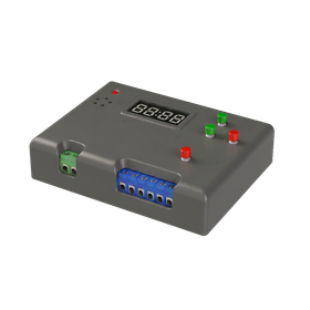
Counter-equipped contact output receiver

Smart management of contracts and work without a PC! 'Receiver with counter output.'

■ Main Features No need for PC or tablet! Achieves standalone count management It receives wireless signals from sending devices (such as tools and sensors) and displays the count value in real-time on the main unit's digital display. Even in workspaces with limited space where it is difficult to install terminals like computers, you can easily manage fastening counts and create a poka-yoke environment. Memory function ensures safety even when powered off The set count value is securely retained even when the power is turned off. There is no hassle of resetting it every time you start up. Customizable count program The program (settings) can be flexibly switched according to the operational rules of the site. System integration via PLC connection is also possible In addition to standalone use, it is possible to connect relay outputs (count completion signals) and clear signals to a PLC, enabling advanced fastening management (process poka-yoke) integrated with the entire system of the line.

  • PLC
  • relay
  • Other Sensors
  • Receiver

Added to bookmarks

Bookmarks list

Bookmark has been removed

Bookmarks list

You can't add any more bookmarks

By registering as a member, you can increase the number of bookmarks you can save and organize them with labels.

Free membership registration

HDMI network transmitter and receiver (CAT6A type)

CAT6A cable transmission type! It can transmit HDMI signals up to 4K60/4:4:4 over a distance of up to 100 meters.

The "NEX-02T/HC・NEX-02R/HC" is a transmitter and receiver that can transmit HDMI signals up to 4K60/4:4:4 over CAT6A cables for distances of up to 100 meters. In addition to video and audio signals, it can also transmit LAN up to 1000BASE-T. By combining it with controllers and applications for NEX-SMART and 10GbE switches, you can build multi-distribution and matrix configurations. 【Features】 ■ Capable of transmitting HDMI signals up to 4K60/4:4:4 visually losslessly over distances of up to 100 meters ■ The transmitter is equipped with an EDID emulator function and an HDMI through output terminal ■ The transmitter has an analog audio input terminal, allowing long-distance transmission similar to video signals ■ The transmitter can de-embed HDMI audio signals and output them as analog audio ■ The receiver can output HDMI to two distribution outputs ■ USB HID can also be transmitted *For more details, please refer to the PDF materials or feel free to contact us.

Added to bookmarks

Bookmarks list

Bookmark has been removed

Bookmarks list

You can't add any more bookmarks

By registering as a member, you can increase the number of bookmarks you can save and organize them with labels.

Free membership registration