No monthly running costs, no maintenance fees! Real-time display of the current seismic intensity! Alerts/warnings for seismic intensity above the specified level! Equipment can also be controlled!
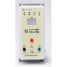
The "Burutto S-Wave," a real-time seismic intensity meter (seismometer), measures the current seismic intensity of shaking earthquakes using a three-axis accelerometer. When a pre-set seismic intensity is detected, it notifies alarms through LED lights, buzzers, and external outputs, aiming to mitigate earthquake damage. By utilizing the Burutto S-Wave, control of external devices, measures against direct earthquakes, and countermeasures against false emergency earthquake alerts become possible. A symbol of trust, MADE IN JAPAN.
【Main Features】
- Measures the current real-time seismic intensity and notifies alarms when a specific intensity is detected. You won't miss the timing of the alarm!
- No running costs such as maintenance fees, server usage fees, or contract renewal fees (excluding electricity costs).
- Simply install it on a wall or similar surface, dramatically reducing installation costs.
- In addition to setting the seismic intensity for alarms, it is also possible to set a seismic intensity for advisories.
- External device control is possible not only at alarm intensity but also at advisory intensity.
- When linked with emergency earthquake alerts, it enables responses to direct earthquakes, eliminates false alarms, and ensures more reliable safety.
- In test and training mode, it is possible to conduct control tests of broadcasting equipment, patrol lights, external devices, and disaster prevention training (optional).
- Company:Jコーポレーション
- Price:100,000 yen-500,000 yen


![Digital Simple Radio Individual Receiver (for Licensed Stations) [XEAL40D]](https://image.mono.ipros.com/public/product/image/391/2001035601/IPROS15744621094997129706.jpg?w=280&h=280)
![Digital Simple Radio Individual Receiver (for Registered Stations) [XEAL3D]](https://image.mono.ipros.com/public/product/image/364/2001035676/IPROS16042421830274387525.jpg?w=280&h=280)
![Digital Simple Radio Individual Receiver (for Licensed Stations) [XEAL4D]](https://image.mono.ipros.com/public/product/image/e75/2001035683/IPROS8625987448560897741.jpg?w=280&h=280)

![[Professional Vehicle-mounted Device] Digital General Business Radio IC-DU6010S1](https://image.mono.ipros.com/public/product/image/2000423662/IPROS13157842122657087964.jpg?w=280&h=280)


![[No license or qualifications required] Digital guide system receiver DJ-RX80](https://image.mono.ipros.com/public/product/image/862/2001050247/IPROS45610397082429463092.jpeg?w=280&h=280)
![[1.9GHz Band] WX-SR202DAN/WX-SR204DAN](https://image.mono.ipros.com/public/product/image/ca8/2001069272/IPROS31475926785965225097.jpeg?w=280&h=280)


![[Contract Achievements] 800MHz Band Wireless Microphone & Receiver](https://image.mono.ipros.com/public/product/image/8ea/2000419112/IPROS10203748154444620551.jpg?w=280&h=280)