[Development Achievements] Digital Content: Disaster Evacuation VR App
 Shrewd Sekkei Co., Ltd.
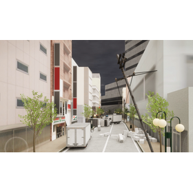
The "Disaster Evacuation VR App" developed by our company utilizes 3D scanning measurement services and laser scanning to accurately recreate real cityscapes through point cloud data analysis. This enables safe data acquisition using non-contact measurement services and simulates disasters such as fires and tsunamis with realistic 3D models. We provide a system that allows for the experience and training of evacuation behavior within a VR space.
【Customer Feedback】
- It's hard to visualize actual disaster response with just hazard maps.
【Implementation Effects】
- Improved realism by integrating aerial data from 360-degree cameras and drones.
- Utilization of detailed 3D city data through digital twin technology.
- Incorporation of point cloud measurements by robots to create a realistic evacuation experience with the latest technology.
【Application Fields】
Education and Administration
This is next-generation digital content that contributes to enhancing disaster prevention education and local disaster response plans.
*For more details, please feel free to contact us.
Inquiry about this news
Contact Us OnlineMore Details & Registration
Details & Registration