Responding to AGV position shifts and environmental changes! Achieving high-precision self-position estimation with Visual SLAM.
In AGVs and autonomous robots, it is necessary to accurately grasp the destination and current position to determine the travel route. This solution customizes Toshiba's unique self-position estimation technology for your system and optimizes it for real-time systems. ■ Do you have any of these challenges? - Want to improve the self-position estimation accuracy of AGVs and transport robots - Want to reduce position drift and cumulative errors that occur during long-distance travel - Want to implement SLAM that is robust to environmental changes such as ambient light, lighting, and moving obstacles - Want to combine multiple sensors such as cameras, LiDAR, and IMUs - Want to achieve autonomous driving in areas where GPS/GNSS signals are unstable - Want to generate an environmental map while simultaneously estimating self-position - Need a fast, low-memory SLAM that operates on embedded devices - Want to customize SLAM to fit your own robots or mobile units ■ Would you like to solve these challenges with SLAM? We support self-position estimation tailored to your system by combining Visual SLAM, Visual Relocalizer, landmark-based SLAM, sensor fusion, and environmental map generation.
Inquire About This Product
Related Videos
basic information
We provide Toshiba's unique self-position estimation technology optimized for real-time use for AGVs and autonomous systems. ◆ Three Visual SLAM Technologies - "Landmark based SLAM," which performs absolute self-position estimation based on landmarks such as QR codes. - "Visual Relocalizer," which automatically finds feature points from the scenery to perform absolute self-position estimation. - "Visual SLAM," which utilizes the "appearance" of images captured by the camera to perform relative self-position estimation. By combining these technologies, high-precision self-position estimation is possible. ◆ Improved Accuracy and Robustness through Sensor Fusion In Visual SLAM and IMU, issues such as error accumulation during long-distance movement and the effects of environmental changes and noise are challenges. We combine multiple sensors to address these issues and achieve high-precision and stable self-position estimation. ◆ Environmental Recognition through Surrounding Map Generation Based on environmental information, we can generate a spatial map of the surroundings in real-time while performing self-position estimation. The environmental map generation function can be utilized for surrounding recognition, enabling applications such as obstacle avoidance, harvesting robots, and picking in warehouse robots.
Price information
Please feel free to contact us with any questions or requests for quotes. Our products and services are sold to companies, organizations, and corporations.
Delivery Time
Applications/Examples of results
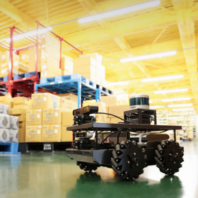
■Use Cases in Factories and Warehouses By utilizing SLAM with unmanned transport vehicles (AGVs) that operate in factories and warehouses, we can improve efficiency, safety, and autonomy. - Applicable to robots that pick up products from warehouses - Adapt to new obstacles caused by the movement of items, as well as changes in the environment such as natural light and lighting - By combining multiple sensors, we can integrate diverse information to achieve robust position estimation and environmental map generation. ■Use Cases in Farms and Orchards Autonomous tractors moving outdoors face several challenges. By optimizing sensors and improving algorithms, we enhance the safety and efficiency of autonomous tractors in outdoor settings. - When GPS signals are unstable outdoors, SLAM technology can be used to identify the tractor's position in real-time - Create environmental maps by combining LiDAR, sensors, cameras, etc., enabling alignment and surrounding environment recognition - Capable of avoiding obstacles such as trees and rocks, and applicable for recognizing fruits at harvest time and for harvesting robots - Adaptable to various terrain changes, such as between rows and slopes.
catalog(1)
Download All Catalogs
Company information

We will provide optimal solutions that contribute to our customers' businesses through our "extensive experience and achievements accumulated over many years" and "high technical capabilities" in the fields of embedded and LSI design.