List of Earth Sciences products

  • classification:Earth Sciences

1~15 item / All 36 items

Displayed results

Reduce the workload from handling heavy objects! Here are five case studies that solved customer challenges! We are also accepting free consultations and tests tailored to your work!

  • PRエリア.png
  • Other conveying machines

Added to bookmarks

Bookmarks list

Bookmark has been removed

Bookmarks list

You can't add any more bookmarks

By registering as a member, you can increase the number of bookmarks you can save and organize them with labels.

Free membership registration

No more need to lift heavy one-gallon cans! Enjoy comfortable liquid transfer in the central kitchen.

  • Other Pumps

Added to bookmarks

Bookmarks list

Bookmark has been removed

Bookmarks list

You can't add any more bookmarks

By registering as a member, you can increase the number of bookmarks you can save and organize them with labels.

Free membership registration
画像1.jpg

Decision to exhibit at the 1st Chubu Food Industry Creation Exhibition '26!

We will be exhibiting at the "1st Chubu Food Industry Creation Exhibition '26" to be held at Port Messe Nagoya from November 4 (Wednesday) to November 6 (Friday), 2026. As a new addition to our lineup, we will showcase the "Cordless Sanitary Handy Pump," which is a product we started selling in April last year, alongside our "Compact Sanitary Handy Pump Model MHS." - Cordless! Portable anywhere! Easy to use! Simple cleaning! It is compatible with standard 18L cans and BIB (Bag-in-Box) and features a structure that allows for easy disassembly and cleaning. We would like to invite you to visit us at this opportunity. - Venue: Port Messe Nagoya - Our exhibition booth: Hall 1 "C-66"
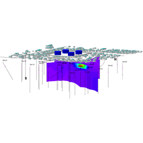
Software for the management, analysis, and visualization of geological information for the environment, geotechnical engineering, mining, and the petroleum industry.

  • Earth Sciences
  • Distance measuring device
  • Other measurement, recording and measuring instruments

Added to bookmarks

Bookmarks list

Bookmark has been removed

Bookmarks list

You can't add any more bookmarks

By registering as a member, you can increase the number of bookmarks you can save and organize them with labels.

Free membership registration

An example of the application of geothermometry analysis to estimate the temperature of geothermal fluids existing in underground structures.

  • Software (middle, driver, security, etc.)
  • Earth Sciences
  • Other water quality analysis

Added to bookmarks

Bookmarks list

Bookmark has been removed

Bookmarks list

You can't add any more bookmarks

By registering as a member, you can increase the number of bookmarks you can save and organize them with labels.

Free membership registration

Visualize sunlight simulation with Surfer to maximize real estate value.

  • Earth Sciences
  • Distance measuring device
  • Other measurement, recording and measuring instruments

Added to bookmarks

Bookmarks list

Bookmark has been removed

Bookmarks list

You can't add any more bookmarks

By registering as a member, you can increase the number of bookmarks you can save and organize them with labels.

Free membership registration

Strong support for the design and analysis of solar power generation systems.

  • Earth Sciences
  • Distance measuring device
  • Other measurement, recording and measuring instruments

Added to bookmarks

Bookmarks list

Bookmark has been removed

Bookmarks list

You can't add any more bookmarks

By registering as a member, you can increase the number of bookmarks you can save and organize them with labels.

Free membership registration

Accurate 2D and 3D topographic maps with an easy-to-understand interface.

  • Earth Sciences
  • Distance measuring device
  • Other measurement, recording and measuring instruments

Added to bookmarks

Bookmarks list

Bookmark has been removed

Bookmarks list

You can't add any more bookmarks

By registering as a member, you can increase the number of bookmarks you can save and organize them with labels.

Free membership registration

Create detailed 2D and 3D contour and topographic maps with an easy-to-understand interface.

  • Earth Sciences
  • Distance measuring device
  • Other measurement, recording and measuring instruments

Added to bookmarks

Bookmarks list

Bookmark has been removed

Bookmarks list

You can't add any more bookmarks

By registering as a member, you can increase the number of bookmarks you can save and organize them with labels.

Free membership registration

Maximize the appeal of tourist destinations with beautiful 2D and 3D topographic maps.

  • Earth Sciences
  • Distance measuring device
  • Other measurement, recording and measuring instruments

Added to bookmarks

Bookmarks list

Bookmark has been removed

Bookmarks list

You can't add any more bookmarks

By registering as a member, you can increase the number of bookmarks you can save and organize them with labels.

Free membership registration

Support for the visualization and analysis of terrain data in agriculture.

  • Earth Sciences
  • Distance measuring device
  • Other measurement, recording and measuring instruments

Added to bookmarks

Bookmarks list

Bookmark has been removed

Bookmarks list

You can't add any more bookmarks

By registering as a member, you can increase the number of bookmarks you can save and organize them with labels.

Free membership registration

Software that visualizes the terrain of archaeological sites and streamlines excavation research.

  • Earth Sciences
  • Distance measuring device
  • Other measurement, recording and measuring instruments

Added to bookmarks

Bookmarks list

Bookmark has been removed

Bookmarks list

You can't add any more bookmarks

By registering as a member, you can increase the number of bookmarks you can save and organize them with labels.

Free membership registration

Solving forest management challenges through the visualization of forest data.

  • Earth Sciences
  • Distance measuring device
  • Other measurement, recording and measuring instruments

Added to bookmarks

Bookmarks list

Bookmark has been removed

Bookmarks list

You can't add any more bookmarks

By registering as a member, you can increase the number of bookmarks you can save and organize them with labels.

Free membership registration

Software for creating 2D and 3D topographic maps to visualize flood risks and strengthen disaster prevention measures.

  • Earth Sciences
  • Distance measuring device
  • Other measurement, recording and measuring instruments

Added to bookmarks

Bookmarks list

Bookmark has been removed

Bookmarks list

You can't add any more bookmarks

By registering as a member, you can increase the number of bookmarks you can save and organize them with labels.

Free membership registration

Software for creating 2D and 3D topographic maps to visualize pollution conditions and accelerate analysis.

  • Earth Sciences
  • Distance measuring device
  • Other measurement, recording and measuring instruments

Added to bookmarks

Bookmarks list

Bookmark has been removed

Bookmarks list

You can't add any more bookmarks

By registering as a member, you can increase the number of bookmarks you can save and organize them with labels.

Free membership registration

Create detailed 2D and 3D topographic maps with an easy-to-understand interface.

  • Earth Sciences
  • Distance measuring device
  • Other measurement, recording and measuring instruments

Added to bookmarks

Bookmarks list

Bookmark has been removed

Bookmarks list

You can't add any more bookmarks

By registering as a member, you can increase the number of bookmarks you can save and organize them with labels.

Free membership registration

2D and 3D topographic mapping software to support resource quantity evaluation in mining.

  • Earth Sciences
  • Distance measuring device
  • Other measurement, recording and measuring instruments

Added to bookmarks

Bookmarks list

Bookmark has been removed

Bookmarks list

You can't add any more bookmarks

By registering as a member, you can increase the number of bookmarks you can save and organize them with labels.

Free membership registration

Software for creating 2D and 3D topographic maps to streamline earthwork calculations.

  • Earth Sciences
  • Distance measuring device
  • Other measurement, recording and measuring instruments

Added to bookmarks

Bookmarks list

Bookmark has been removed

Bookmarks list

You can't add any more bookmarks

By registering as a member, you can increase the number of bookmarks you can save and organize them with labels.

Free membership registration

Filter

classification
Delivery Time
Location