

Linking operational status data and maintenance history to 3D models! We will introduce a case where progress is visualized in real-time for all stakeholders.
We will introduce a case where 3D data before and after construction is regularly updated and serves as the foundation for project progress management during large-scale renovations. Operational status data and maintenance history are linked to equipment pins on the 3D model, enabling intuitive management. On the "FACTORY 3M CLOUD," all stakeholders can visualize progress in real-time, allowing for intuitive asset management. [Case Overview] ■ Asset management through linking equipment ledgers and 3D models ■ Foundation for project progress management during large-scale renovations ■ Linking operational status data and maintenance history to equipment pins on the 3D model ■ Real-time visualization of progress for all stakeholders *For more details, please download the PDF or feel free to contact us.

Inquire About This Product
basic information
【Main Features】 ■ View/Share data such as point clouds and 3D models on the cloud ■ Data comparison ■ Measurement function ■ Crop function ■ Annotation and tagging function/Real-time sharing via email ■ Automatic mesh modeling of point clouds ■ Time runner function *For more details, please download the PDF or feel free to contact us.
Price range
Delivery Time
Applications/Examples of results
For more details, please download the PDF or feel free to contact us.
catalog(2)
Download All Catalogs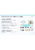
Company information

Kimo Co., Ltd. is a company that supports digital transformation (DX) in manufacturing sites and promotes work style reform, thereby enhancing corporate competitiveness. We digitalize and streamline "paper and manual-based business processes" and "personalized information management" that are rooted in the field, achieving sustainable growth. Additionally, we are engaged in high-performance materials businesses such as the development and manufacturing of high-functionality films, as well as digital twin businesses including spatial information and image editing/system development.

