
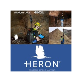
Equipped with two laser scanners oriented horizontally and vertically, it stably acquires point cloud data in all 360 degrees just by walking!
【Subsidy-Eligible Product】The 'HERON PORTABLE 3D MAPPING SYSTEM (Backpack-type Laser Scanner)' is equipped with two laser scanners oriented horizontally and vertically, allowing for the acquisition of 360-degree point cloud data simply by walking. It simultaneously captures Full HD video (1920×1080 pixels / 15fps) while scanning, and for areas requiring high-resolution images, it can stop to take 5K still images (5640×2820 pixels). The tablet device in hand displays 3D data in real-time, enabling measurements while confirming that data is being accurately captured, making it a backpack-type 3D laser scanner. 【Features】 ■ Lightweight ■ Time and cost-saving ■ Usable indoors and outdoors ■ Real-time 3D measurement ■ Easy setup ■ Walking measurement capability ■ Easy tablet verification ■ Simple software processing *For more details, please refer to the PDF document or contact us directly. ★ This product is a surveying instrument eligible for "subsidy utilization" upon purchase. It may be available for purchase at 1/2 to 1/3 of the regular price! If you are interested, please feel free to contact us.
Inquire About This Product
basic information
【Other Features】 ■ Measurement Range: 1m - 100m ■ Relative Accuracy: ±5cm ■ Repeatability Accuracy: ±2cm ■ Initialization Time: 30 seconds ■ Battery Operation: 2 hours ■ Scanning Rate: 600,000 points/second ■ Field of View: 360 degrees x 360 degrees ■ Laser Class: Class 1 ■ Laser Wavelength: 903nm ■ Operating Ambient Temperature: -10 to 45 degrees ■ Weight: Approximately 7.8kg (including battery and tablet device) 1. 360-degree Street View (15fps): Viewable from any location 2. Automatic Creation of Plan Ortho Images: Automatically generates ortho images from point cloud data 3. Photo/Point Cloud Toggle Slider: Switch between photos and point clouds in Street View 4. Video Playback Button: Play videos (15fps) to view the surrounding conditions during measurement 5. 5K Still Image Capture: Capable of obtaining 5K high-resolution 360-degree images *For more details, please refer to the PDF document or feel free to contact us.
Price range
Delivery Time
Applications/Examples of results
For more details, please refer to the PDF document or feel free to contact us.
catalog(13)
Download All Catalogs
![[Eligible for IT Introduction Subsidy!] Electronic Tablet and Surveying CAD System 'WingNeo INFINITY 2024' Materials](https://image.mono.ipros.com/public/catalog/image/01/543/728375/IPROS72705894412853466456.jpeg?w=120&h=170)






![[Attention Kanagawa Prefecture Entrepreneurs!] Subsidy for the Promotion of Productivity Improvement for Small and Medium Enterprises in Fiscal Year 2024](https://image.mono.ipros.com/public/catalog/image/01/3b5/750199/IPROS62197564750867279215.jpeg?w=120&h=170)
![[Attention businesses in Chiba Prefecture!] Subsidy for the Promotion of Productivity Improvement for Small and Medium-sized Enterprises in Fiscal Year 2024](https://image.mono.ipros.com/public/catalog/image/01/bf1/750296/IPROS78027748981470429568.jpeg?w=120&h=170)
![[Application Support Starts!] 12th Business Restructuring Subsidy](https://image.mono.ipros.com/public/catalog/image/01/c3f/757281/IPROS59625525207041781239.jpeg?w=120&h=170)
Company information
Yokohama Measuring Instruments Co., Ltd. is engaged in the sale, repair, maintenance, and rental of surveying instruments (general surveying instruments, GNSS, laser scanners, etc.), surveying CAD software, multifunction office equipment, and other related products. We offer a lineup of products from various manufacturers, including Leica, Topcon Sokkia, and Pentax. Please feel free to contact us if you have any requests. We have established a new consulting division to support subsidy applications. We provide support for two types of subsidy applications: "Monozukuri Subsidy" and "Business Restructuring Subsidy." Our company will comprehensively support the necessary business plans and application procedures required for the application process. If you have any other questions, please do not hesitate to let us know.
![Measurement and Surveying: Tunnel Measurement Using Ground-Based 3D Laser Scanners [Case Study]](https://image.mono.ipros.com/public/product/image/7ea/2000554148/IPROS04583418328189612968.jpeg?w=280&h=280)
![[Example] Usage of Ground-based 3D Laser Scanner by Kanesugi Construction Co., Ltd.](https://image.mono.ipros.com/public/product/image/4e9/2000681278/IPROS31950373267103053173.png?w=280&h=280)