See Distance Measuring Device's detailed category ranking


High-precision 3D scanning just by walking. A field-complete handheld 3D laser scanner that even beginners can handle.

A diverse range of products using iSafe Laser! Compact and lightweight, yet capable of measuring up to 40 km away!


Measurement of the inner diameter, irregularities, and distortions of large-diameter pipes and tubes can be performed quickly using a 2D laser scanner.

High temperatures, flames, and steam are no problem!


Space-saving parking! A one-person electric mini car with speed and power.


Leave everything from product purchase to calibration, repair, and retrofit to us.

Leave everything from product purchase to calibration, repair, and retrofit to us.


Affordable distance sensors for measuring film and coating thickness, as well as non-contact thickness measurement. Strong performance on slopes, achieving a distance direction resolution of 20nm!


The wafer sensor is a suitable measuring instrument for equipment improvement. It allows for objective measurements and enables easy acquisition of numerical parameters that indicate improvement effects.


Just by attaching it to an existing cutting machine, cutting precision and efficiency are greatly improved!


Compact, lightweight, low-cost model for short distances.

High-performance underwater ultrasonic thickness gauge capable of measurements at depths of up to 300m.


★Good Condition★ Used RC Radar Rebar Detector Handy Search NJJ-200 is available for 1.2 million yen! (Excluding tax) with a guarantee of normal operation and maintenance completed!

Leave everything from product purchase to calibration, repair, and retrofit to us.


An evolved version of the Kilbimeter that allows for the calculation of the area and volume of rectangles and cubes through multiplication functions.


Visualize sunlight simulation with Surfer to maximize real estate value.

Create detailed 2D and 3D contour and topographic maps with an easy-to-understand interface.

Surface sensors for intrusion monitoring.


A device that performs the functions of two or three roles in one unit! A crane proximity detection device with built-in distance functionality.


[Concern] I want to measure the PCD and PCR of a hole.

You can easily measure any shape of line, regardless of scale! The operation is also simple.

Dimetix laser distance sensors are used in industrial applications around the world. They achieve high-speed measurements of 250Hz and are compliant with IP65.

When transporting heavy objects, retrofitting a laser distance sensor to an existing overhead crane allows for measuring position information and controlling to avoid collisions through coordinate management.

Software for creating 2D and 3D topographic maps to streamline earthwork calculations.


Measured in a pasture of about 7 hectares! A demonstration was conducted with a flight time of approximately 13 to 14 minutes.


The new cable length measuring device 'TV220E' can detect instantaneous cable faults without missing them, and also allows for comparative display of measurement results with the "two-phenomenon comparison"!


Compact NMR optimized for dispersion evaluation.


Traffic safety measures near the entrance and exit of the work site!


Differential transformer (displacement sensor) optimal for displacement detection requiring high precision and high reliability.

GNSS receiver tablet device equipped with Windows 10


[Sample loan available!] Standard set of absolute type with a compact head of 65mm width, resolution 0.01mm.


Compact laser distance sensor capable of high-precision and long-range measurement.


Prevent contact with high-voltage lines and heavy machinery! Detect objects entering the barrier! Measurement possible even through glass.


An absolute linear displacement sensor that excels in environmental resistance and can be used under vibration, shock, and high-temperature conditions.


Standard-equipped with linearization processing functions! A richly expressive meter relay.


Narrow FOV 60°x28.5°, ultra-high resolution 6 million points/second, ideal for obstacle detection on railway vehicles and highways, as well as drone detection from above.


Diameter measuring tape: Simply roll it out and read the scale to measure in units of 1/100 mm. Ideal for measuring large outer diameters, inner diameters, and the inner diameter of O-rings.


We have housed fiber optic photoelectric sensors released by major companies in a pressure-resistant explosion-proof box and obtained labor inspection certification! Accurate detection in hazardous locations is possible!

A mid-range thickness gauge equipped with a variety of functions that supports all types of measurements with a 5-level sensitivity adjustment feature.

The ideal thickness gauge for measuring container thickness, capable of easily and accurately measuring complex shapes.


Positioning with an error of a few centimeters using RTK technology. Establishing unique reference points at over 3,300 locations nationwide.


It is a level that uses a built-in highly sensitive tubular bubble tube to determine the horizontal position of the machine.


Active as a positioning device for molds in numerous press machines both domestically and internationally! Prevents failures, damage, and cracks in press machine molds before they occur!


Distributing reference station data (RINEX data) used for PPK and post-processing analysis in GNSS positioning! Utilized in MMS, aerial surveying, and drone surveying.

[Concern] I want to create or repair a high-quality whetstone molding template.

Based on the product drawings for inspection, we will design and manufacture a master gauge. Using the master gauge, anyone can perform product inspections and quality control in a short amount of time.

We will respond to your concerns about measuring the depth of holes and the depth of seatings with custom gauges.


Visualizing archaeological sites with high-precision 3D data! Streamlining research and documentation.

Japan Radio Radar Detection Device (Reinforced Concrete Detector) RC Radar Handy Search NJJ-200k, a radar specialty store where you can purchase the detection device at a reasonable price!

[Used] RC Radar Detector / Rebar Detector StructureScan SIR-EZ in stock! Guaranteed operation and calibrated before shipping! StructureScan

Measuring distances up to 500m with an accuracy of ±1mm! Maximum measurement rate of 250Hz. Compliant with IP65, suitable for environments up to +60°C. Available for rent.

Improving the reliability of inspections and construction as an alternative to measuring with a tape measure! Easy measurement of guaranteed result data. Numerous achievements in home structures, signals, tunnels, and overhead lines.

This is a building gauge measuring device for railway operators. It can automatically measure tunnel cross-sections. Equipped with a color LCD, it allows for on-site verification of measurement results.

Install laser distance sensors on existing cranes, coordinate the entire factory, digitize transportation routes, and automate measurements that were previously taken manually.

When transporting heavy objects, use a retrofitted laser distance sensor on the overhead crane to measure and control the positioning on the X/Y axis within 50-100 meters.

When transporting heavy objects, position information is measured and controlled using a retrofitted laser distance sensor on the overhead crane for positioning along the X-axis/Y-axis within 50-100 meters.

High-precision 2D laser scanner capable of measuring in horizontal/vertical directions. Achieves measurements of displacement, strain, subsidence, and erosion that were not possible before. [Demo unit available]

High-precision 2D laser scanner that realizes efficiency and labor-saving in furnace inspections.


It is a time-saving tool that smoothly moves the workpiece on a three-dimensional measuring machine or granite surface plate and securely fixes it, thereby increasing productivity. It reduces the setup time for workpiece fixation!


Introduction to the features of the NK-2000, including processing surface edge detection, zoom-up function, and calculation capabilities!


A long measuring system that requires compactness can be widely considered in various specifications.

High precision, high speed, and low-cost single-point sensor. A sensor that can be embedded for thickness, distance, and height measurement. Also ideal for semiconductor wafer inspection applications.

Original products from Kurita Techno!! We handle everything from design to development in-house.
Utilizing LiDAR data with Surfer - A combination of point cloud data and surface modeling -

Optimal plot solutions for the environment, water chemistry, and resource/energy sectors.

Accurate 2D and 3D topographic maps with an easy-to-understand interface.

Software for creating 2D and 3D topographic maps to visualize pollution conditions and accelerate analysis.


-New Arrival- Leica DISTO D5 (Leica Dist) package with tripod adapter!!


High-performance distance measuring device suitable for outdoor use.

Landslide monitoring with a laser rangefinder.


Using JIS Level 1 convex! With a 3-hour charge, it can operate for over 8 hours!


WindowsAndroid in-vehicle IoT GPS detects the vehicle's position in urban building areas, under elevated roads, and in tunnels.


Sophisticated and innovative ballistic analysis tool GC4


It is an all-in-one type that can simultaneously observe position, orientation, pitch, and roll!

Anyway, it's easy! Just click. With the use of telecentric lenses on both sides, highly accurate automatic image dimension measurement is possible!


Standard general-purpose measuring instrument


The weight is approximately 15g, making it the smallest and lightest model from the company. In addition to the low-noise specification, there is also a version with magnetic shielding available.


Using ultrasonic distance detection to detect different solids and liquids.

The EM400-TLD uses time-of-flight (ToF) technology to detect and measure distances to objects.

Protecting critical infrastructure from GNSS interference.

Capable of generating and transmitting jamming signals and spoofing signals.


This is an absolute type linear sensor that can be used at high temperatures of 150℃.

Ready to use right after purchase! Comes with a display, magnetic encoder "SI-140 Package" length measurement system, also for Kaizen proposals.

The repeat accuracy of the work cutting machine is not as expected! Here is an example of the introduction of a linear encoder system!

Non-contact linear measurement over a range of 15mm. Absolute output voltage 1-5V. Also suitable for fine adjustments in positioning.

The MP series, which has received great reviews, now includes a lot type: Absolute linear displacement sensor.
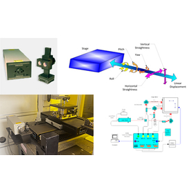

NIST/ISO compliant laser interferometer (displacement meter) capable of easy and precise measurement of up to 6 axes simultaneously.

Ultra-compact yet offering the highest reliability, resistance to stray light, and outstanding cost performance.