
[Subsidy-eligible products] Achieve 3D modeling at low cost with ultra-fast and ultra-high precision scanning! Providing new solutions that were previously difficult to realize!
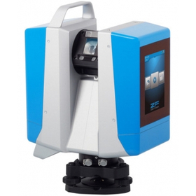
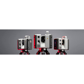
The "PENTAX Z+F IMAGER 5016 Laser Scanner" achieves high precision and high scan rates with low range noise without compromising on advantages, while being equipped with advanced HDR camera features, an integrated navigation system, and high-speed Wi-Fi, all in a compact and lightweight design! Standard LED lights are included for color photography in dark environments (capable of illuminating up to 10m). Equipped with high-speed Wi-Fi, it enables real-time data transfer to a Tablet PC using the included IMAGER5016 dedicated software 'LC SCOUT'! It allows for simultaneous verification of 3D point cloud data during measurement, significantly improving productivity. 【Features】 ■ Achieves 3D reality capture in a short time ■ Portable design that can be stored in a backpack *For more details, please refer to the PDF materials or feel free to contact us. ★ This product is a surveying instrument eligible for "subsidy utilization" upon purchase. It may be available for purchase at 1/2 to 1/3 of the regular price! If you are interested, please do not hesitate to contact us.
Inquire About This Product
basic information
【Other Features】 ■ Portable anywhere (ideal for on-site measurement tasks!) ■ Equipped with a 5.7-inch multi-touch screen on the side of the main unit Easy and quick scanning with a smartphone-like operation feel ■ Maximum scan rate of 1.094 million points/second using phase difference method ■ Equipped with an advanced HDR camera ■ Color 3D point cloud data can be obtained in about 3 minutes ■ Equipped with LED light (can illuminate within 10mm) ■ Accuracy (Linearity Error) less than 1mm (≦1mm) ■ Dustproof and waterproof standard IP 54 ■ Protects the light-receiving lens, which affects the quality of measurement data, with a 99% light transmittance glass cover ■ Using 'LC SCOUT' on-site allows for real-time high-speed data transfer Measurement data in 3D point cloud can be immediately confirmed on-site during measurement! *For more details, please refer to the PDF document or feel free to contact us.
Price range
Delivery Time
Applications/Examples of results
For more details, please refer to the PDF document or feel free to contact us.
catalog(11)
Download All Catalogs
![[Subsidy-eligible product] Laser scanner 'Leica ScanStation P50'](https://image.mono.ipros.com/public/catalog/image/01/cae/426979/IPROS27342789044026833293.jpeg?w=120&h=170)
![UAV Laser Surveying System UL-1 [Discontinued]](https://image.mono.ipros.com/public/catalog/image/01/a34/507039/IPROS31283546511752388759.jpeg?w=120&h=170)
![[Subsidy-eligible product] PENTAX Z+F IMAGER5016 Laser Scanner](https://image.mono.ipros.com/public/catalog/image/01/2e7/606864/IPROS52783956900246676094.jpeg?w=120&h=170)




Company information
Yokohama Measuring Instruments Co., Ltd. is engaged in the sale, repair, maintenance, and rental of surveying instruments (general surveying instruments, GNSS, laser scanners, etc.), surveying CAD software, multifunction office equipment, and other related products. We offer a lineup of products from various manufacturers, including Leica, Topcon Sokkia, and Pentax. Please feel free to contact us if you have any requests. We have established a new consulting division to support subsidy applications. We provide support for two types of subsidy applications: "Monozukuri Subsidy" and "Business Restructuring Subsidy." Our company will comprehensively support the necessary business plans and application procedures required for the application process. If you have any other questions, please do not hesitate to let us know.
![[End] "Utilization of Scanners/Point Clouds and Introduction of Available Subsidies"](https://image.mono.ipros.com/public/product/image/299/2000684011/IPROS35417378866815657788.jpeg?w=280&h=280)
![[Use Case] Factory Renovation Project: Creating Drawings from Point Cloud Data](https://image.mono.ipros.com/public/product/image/6ae/2000700205/IPROS92701705356590289305.png?w=280&h=280)
![[Case Study Collection] GS-1](https://image.mono.ipros.com/public/product/image/054/2001416936/IPROS12412343509502025986.png?w=280&h=280)
![Laser Scanner Leica BLK360 [Rental] [Sale]](https://image.mono.ipros.com/public/product/image/9f6/2000586732/IPROS97254022099824981056.jpeg?w=280&h=280)